In the real cold winter time 2017/18 I was bored and thought about my current way of navigation DURING my RIDES. For about 2 years (+30000km or 18600mi) I was using a Garmin Montana 650T rugged outdoor navigation device for doing my off road adventures. It worked ok – NOT more or less. Its old hardware, THE sometimes buggy software, the bad display, processing time, etc. made the decision easy for me to get rid of it. In my opinion this device is antiquated compared to the features a smartphone offers. A look to other current / actual new motorcycle navigation systems showed the same. They are far behind in many properties a smartphone offers for off road navigation.
So the decision was made: In future I will use a Android smartphone for navigation!
The following information I published in the year 2018 in the www on sites like the TET-forum or on ADVRIDER. It starts with my first try of such kind of smartphone navigation and ends in my current setup. My actual navigation setup is located on the end of that big page.
So here is the full story from its beginning to the present…
THE BASIC SETUP:
I was using a Sony Xperia Z5 Compact since about 2 years without any big troubles. I thought to myself lets stay with it. I bought another one used for 130 Euro.
Its Hardware is strong, the screen is bright enough (also in the sunlight), it has a glove mode, it has IP67 certification (also its flap-less USB socket is IP67 certified) and with Android 7.0 it will work with the incoming apps of the next few years. So it will be a good navigation device.
This smartphone is only one part of the setup. What is also needed?:
For getting energy a waterproof 12V DC to USB converter (3 Euro):
KLICK
A ultra thin AND WATERPROOF Qi-wireless charging pad powered via USB (1 Ampere Charging Power) (15 Euro) :
KLICK
For mounting the phone/charging pad @ the handlebar a RAM MOUNT X GRIP and a fitting mount for the handlebar (50 Euro):
KLICK
A ultra thin Qi Charging receiver with micro USB inlet because the Z5 Compact didn’t have built in wireless charging (2 Euro):
KLICK
The smartphone itself is protected with a heavy rugged case from the company “Lovemei”: (alloy frame, rubber damping, gorilla glass screens protection and without additional waterproof ability) (10 Euro):
KLICK
Here are some pictures:

The equipment from L to R: Ram Mount X Grip, power converter, Qi-charger, Qi-receiver, smartphone +heavy duty case.

Smartphone + heavy duty case.

Ram X Grip with glued on Qi-charger.

That´s the mounted state of the cradle and phone is loading.
The ultra thin Qi-receiver is glued in between the backside of the pone and the protection case and directly mounted to the micro USB Socket of the phone.
Using it in full navigation mode (GPS on, screen brightness high) it is loading with around one battery percent each 10 to 15 minutes (My biggest concern was, that it won´t be able to charge the battery enough).
Here a comparison between my old Garmin 650t and the new navigation D.I.Y. solution at the same level of map zoom and at full brightness: (both devices using OSM Map material):

The result is obvious, isn`t it?
—
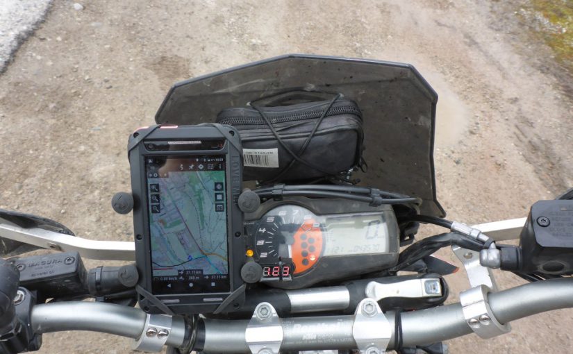
Finally I mounted the D.I.Y. Navigation System on my 690:


After navigating about 2000km with this solution i was really satisfied with it.
The screen is good readable (better than that on the Garmin) and offers more details than the Garmin Montana did. Also the glove mode works well, and the zoom in/out via volume button is a nice handy feature.
The mount itself holds the device well in position with its rubber net. The only contra point is that it is a bit fiddly to put the device in/out of the cradle.
Therefore, maybe one of these will be a better solution: KLICK
MY APPS
Lets start with the home screen:
I´m using as lucid alternate home screen the App “LAUNCHER 8”. It is simulating a big tile windows phone desktop, witch is highly configurable.
For easy Handling i arranged it as follows:

On top: GSAM Battery Monitor widget for checking Loading state/current
—
1.) The first tile is a Shortcut to the navigation app called “MAPSME”:
The App Mapsme is working completely offline. It is offering detailed OSM maps, which you can install easily directly from the app on your android device.
There are also loads of POIs included like: sights, restaurants, fuel stations, workshops, ATMs, cat houses ^^, camping grounds, …).
This app I am using only for simple A to B routing on paved streets. Most of the time in case when a fast detour is needed.
It´s good working on the small phone screen and allows to modify the calculated route via intermediate points. Screenshots MAPSME:

App: MAPSME (earlier name: Maps with me)

2.) The second tile leads to the navigation app ORUXMAPS: ORUXMAPS is AWESOME and MIGHTY. Nearly as almighty as the payed version of Locus Maps! BUT its for free and without any adds!
This App is handling loads of routing, tracking and map formats completely offline. (Since doing more and more off road riding I am using OSM Material for tracks aside paved streets. The reason for this is, that OSM Maps are really high detailed regarding gravel and single tracks. IMO no other navigation system provider is delivering such a detailed Map Material. If they do, they use themself OSM as a source ^^)
ORUXMAPS is offering many different navigation profiles. (Hiking, Car, Mountain bike, …).
Depending on which profile you choose, ORUXMAPS shows you the resulting tracks/streets on the OSM map. (I´m using mostly the Mountain bike profile).
Additionally you can choose yourself what ORUXMAPS will show you on the map (only show streets and gravel tracks and no hiking/climbing trails). There are also different overlays for it (paper map design, Maps forge design, topomap, Altitude lines, …).
Also it´s possible to draw map overlays, hints, etc. directly as overlay on the map. Thats very helpful when you are on your way and get some important information from other peoples about your further route, or when you riding the TET and you find some blocked roades, to make a fast note directly onto the map.
This app really doing its job! With the additional routing app BROUTER it will also do the routing job, but therefore I am using the already above mentioned app MAPSME. For off road I am only using pre planned tracks . Here a few pics of ORUXMAPS:

Fully customizable quick buttons (track log, zoom, centre map, …)

Detailed terrain information.

3D sight for checking the terrain. (Here in exaggerated mode)
ORUXMAPS is for free but you won´t find it in the play store due google banned it because of its donating system. You can find it here:
http://www.oruxmaps.com
(I made a donation because this app is just awesome and is really helpful contributing my hobby!)
Btw.: A cool feature of Android is to run 2 navigation apps side by side on the same screen:

On top Oruxmaps, which is following a black track line planed at home on the desktop computer and below is the app Mapsme running parallel with A to B route, planned on the smartphone/navigation system. That’s just genius for cross checking your route.
—
3.) The third tile is leading to the app GPS TEST:
It´s a easy app for forcing a fast GPS fix without internet. It also includes some nice functions like speedometer, time of dusk/dawn, etc.:


4.) The 4th tile: OPERA INTERNET BROWSER:
Not much to say on this. I´m using this browser gladly due its data compression which is handy when having bad internet connection.
On my cellphone its also keep the amount of data low wile watching peps pampering around in the wild. ^^
—
5.) The 5th tile leads to the App: “AUTO BEST BRIGHTNESS LEVEL”:

A click on this tile, a overlay menu is opened for easy and fast adjusting/forcing the desired brightness setting.
—
6.) The last tile is simply entrance point to the cloud app I’m using for transfer the computer planed tracks easily to the navigation system.
PROBLEMS WITH THIS SETUP
After navigating in the year 2018 15000km or +9300mi with this setup I have learned my lessons:
1.) While riding the first time in heavy rain, it showed up that there is a problem with unwanted touchscreen behaviour due to falling rain drops. The solution was to install the app “Touch Blocker-Block Screen touch”. A notification of it is permanent visible at the status bar and with on click you lock the touch ability of the screen. For unlocking the screen you can predefine within the app a simple double, or triple tap gesture. That works really well while riding under wet conditions.
2.) The first real problem with the hardware was, that the cable of the wireless charging pad is really thin and it has to be strengthened with a wire. Without that the 690ty rattle it to dead exactly at the entrance point into the housing of the charging pad.
3.) The used smartphone, a Z5 Compact from SONY was working well with the mentioned after market charging receiver. The only thing I haven´t thought about was electronic corrosion at the USB plug which happens when it´s getting drenched. My fault was, that i haven´t made the plug connection waterproof with a sealant. Due that the USB Port contacts got destroyed after about 15000km by corrosion. So, if you want to use a waterproof smartphone in combination with a external Qi-receiver, make sure that you will seal the port with some silicone, grease or equal! Than it will work properly for a long time.
MY SECOND SETUP SINCE AUTUMN 2018:

Now I am using a old Samsung Galaxy S7 (no edge display). It has integrated Qi-charging, its display is bright enough and it is IP67 certificated. In addition i use a LIFEPROOF CASE for adding extra protection to the phone.

The phone is mounted like on my first setup with a RAM-Xgrip. With the new setup I changed to a long RAM arm to get the phone more in my field of view. That is better when riding in the standing position.

That’s the view from the side.
Overall after now (Decemeber 2019) 25000km or 15500mi/more than a year riding with this new setup I have to say, the Galaxy S7 armoured from the Liveproof Case, is a better permanent smartphone navigation solution than the Z5 compact was.
With a bigger Display and the total isolation from the environment it is working well. The wireless charging power is also high enough for holding the battery’s loading level while the screen brightness is turned to maximum.
The only little annoying thing is that the additional protection case is limiting the glove-touch-ability. With thin leather summer gloves it´s working well, but with thick winter gloves you have to press really hard to get response.
The Z5 Compact did that point better. Overall for me it´s no big contra point. The screen is big enough for showing detailed track information for 800 to 1000m (or 2600 to 3300ft) circuit around the actual position. I am lot less zooming on the S7 than I did with the small Z5 Compact. And hey: Fewer people are riding in winter … . ^_^