“STRATEGICA“
While planning the Project-Carpathian-Balkan-Tour I wasn’t sure how much gravel tracks I should do per day. So I set the focus on some for me important points along the planned route and tried to make a well-balanced mix of on- and off-road riding per day.
This day my personal highlight was surely the “Strategica”. When I first read about it on the internet, this about 50km or 30mi long hilly off road track amazed me. So it was instantly added to my plan for the PCB-route.
Finally, on this riding day I put the so called “Strategica” to the test …

Daily map: On riding day no. 5 Чернотa and I followed some back country roads along the Carpathian Mountains westwards. Near the village Valea Macesului is the entrance point of the Strategica located. From there this old military support line leads up the Carpathian hills and ends after about 50km or 30mi into the famous Romanian Road No. 67C – the “Transalpina”. On the second half of the day we hit hard into the south. Through the Romanian flat lands we went on to the border to Bulgaria. There we crossed via the ferry the border river Danube over to the neighbor country. After a few km in Bulgaria, the day founds its dramatic end after 499km or 310mi of riding … .

This morning I was awoken by the sun which turned the tent instantly into a sauna. So I opened up the tent door and enjoyed the morning mood. This day …

seems to be a beauty. While airing the sleeping bag and the tent I did the morning toilet. After that …

the stuff was packed and stowed swiftly. From the antenna hill where we stayed last night we followed some easy gravel tracks to …

the famous castle of “Bran” . It´s also known as “Draculas Castle“.

While entering the Carpathian mountains we quick gained altitude. The view and the …

streets here have been tremendous to ride.

We passed some classy Romanian houses (BTW.: nice woodwork on top of this one) and stopped around 0900 for a small …

breakfast snack at the Mausoleum Mateias. There at this big grave where the bones from over 2000 Romanian WW1 – Soldiers buried.

After the snack we made a shortcut …

through a few very small and rural Romanian …

villages. As I wrote a few days before …

this type of a “wood working tractor” is very common in the south of Eastern Europe. I like it!

That was interesting: According a mounted plate at the entrance this “Island” in the middle of a river and likewise a tourism center was funded with a big monetary donation from the EU. That wouldn’t be noticeable when there would be any tourism. But here kilometers away from everything there are only abandoned Romanian villages and worse Gravel roads. I’m not sure what’s the plan behind this investment … .

Around 1100 Чернотa and I reached the entrance …

of the above already mentioned “Strategica” track. The ascent …

was easy. Way easier than the tracks in the Ukraine.

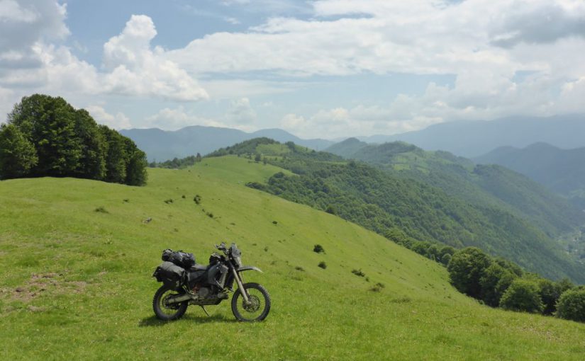
After plenty of gravel bends a short break around midday was taken. Up here …

on top of this hill range it was a pleasure to ride a …

dual sport motorcycle along the meadows.

Short after that great photo …

it began to rain. Because they say misfortune never comes singly, one of the main connecting belts of the soft luggage bags snapped. Due that …

the right bag had contact to the back tire and got worn through. With the bag also the back spare tube, stowed at the bottom of the bag got destroyed. With the usage of some additional rope and luggage straps …

I got it managed to mount the bag in a stable position. So …

my black beauty Чернотa and I went on westwards …

where it started heavily to rain while we passed the …

treeline. Bad weather permanently changed now with some …

dry parts along this great former military support line. At the beginning of June …

you still have to calculate with some snow blocked pieces at the tracks in the Carpathian Mountains. Luckily Чернотa was able to tractor us through a short detour around this impassable snowfield.

The weather was still changing and it got freezing cold up here. Also some parts of the track got …

sluggish. Due to being alone with my black beauty we both rode on carefully, avoiding a pothole surprise.

Near the famous Transalpina Pass Road is the finest …

part of the Strategica located.

There again …

heavy rain drenched us and also this herd of sheep’s got soaked.

After about 50km on the Strategica we reached the main road / the Transalpina.

Here nearly at the highest point of the pass road a big tourism area is located. We rode on along it …

southwards until the sun came out again. As you can see here the self made paper plate, crafted the day before, didn’t survive this days wet conditions high up in the mountains. ^^

Along straight roads …

through Romania’s southern …

flat lands we rode on until …

we reached the border to Bulgaria. Here the stream “Danube” is separating both countries.

Via the ferry boat we crossed the stream. The ferry …

connects the Romanian Village Vama Bechet with the Bulgarian Village Oria Hovo. Click

After about 20 minutes on the ferry we reached Bulgaria. At a gas station near the ferry I fuelled the black beauty up and bought some food. There at the entrance to Northern Bulgaria are giant agrarian fields located. It was late, so I took the chance and built up the shelter in the middle of a remote sunflower field:

After that I repaired my damaged saddle bag:

This repair is working until today but nearly cost me in 2017 a part of the right index finger. o_0
More about how that happened in the next ride report … .

After the repair I was done. I did the highly necessary washing and ate a few biscuits which I bought on the fuel station before. Overall: Despite …

some bad luck, this day of riding was a great one. At least now, looking back to it long afterwards.
To be honest: While taking this photo out of the tent I was really exhausted and concerned about my bad hurt finger. I was hoping not to get blood poisoning or another horrific infection.
Strangely enough I fall asleep really fast.
Total covered distance this day: 499km or 310mi.